Native service request management
Teams can manage requests within Areatec, alongside the location and context of each issue. Request management does not depend on purchasing a separate platform.
Areatec software · public works and road infrastructure
Areatec combines AI road inspection, street asset inventory and native service request management. Vehicles and smartphones capture images and location; teams review the findings and manage requests within the platform. Optional APIs connect to legacy or third-party systems the customer wants to retain.
Road inspection · asset inventory · native requests · optional APIs

Service requests and integration
Finding a street defect and managing the response are different jobs. Areatec supports both: AI road inspection organizes the evidence, while the platform provides native municipal service request management.
Teams can manage requests within Areatec, alongside the location and context of each issue. Request management does not depend on purchasing a separate platform.
Areatec provides APIs for organizations that want to retain legacy or third-party systems. Each project defines shared data, responsibilities, return flows and failure handling.
One pass · multiple assets
The same architecture organizes different observable classes while preserving capture source, location and the history of every record.
Three capture modes
Collection can be vehicle-mounted, performed by field teams or connected to compatible sources defined for the project.
Vehicle capture
Optics, positioning and mounting are defined for the route, operating speed and assets that need to be observed.
Field capture
The dedicated application guides capture, records essential context and sends the material for central processing.
Project sources
Existing images can enter the workflow when quality, context, security and integration meet the requirements defined for the operation.
From the street to management
The workflow combines capture, interpretation, review and service request management. Connecting another system is optional, not a prerequisite for managing requests.
A vehicle, smartphone or compatible source records the scene defined in scope.
Position, route, date, source and operating parameters accompany the image.
Proprietary AI locates assets and suggests observable classes and conditions.
The responsible team examines context and applies the operation's technical criteria.
Teams manage service requests within the platform or use APIs to connect the customer's chosen systems.
Map, mosaic and history support comparison across routes, segments and later inspections.
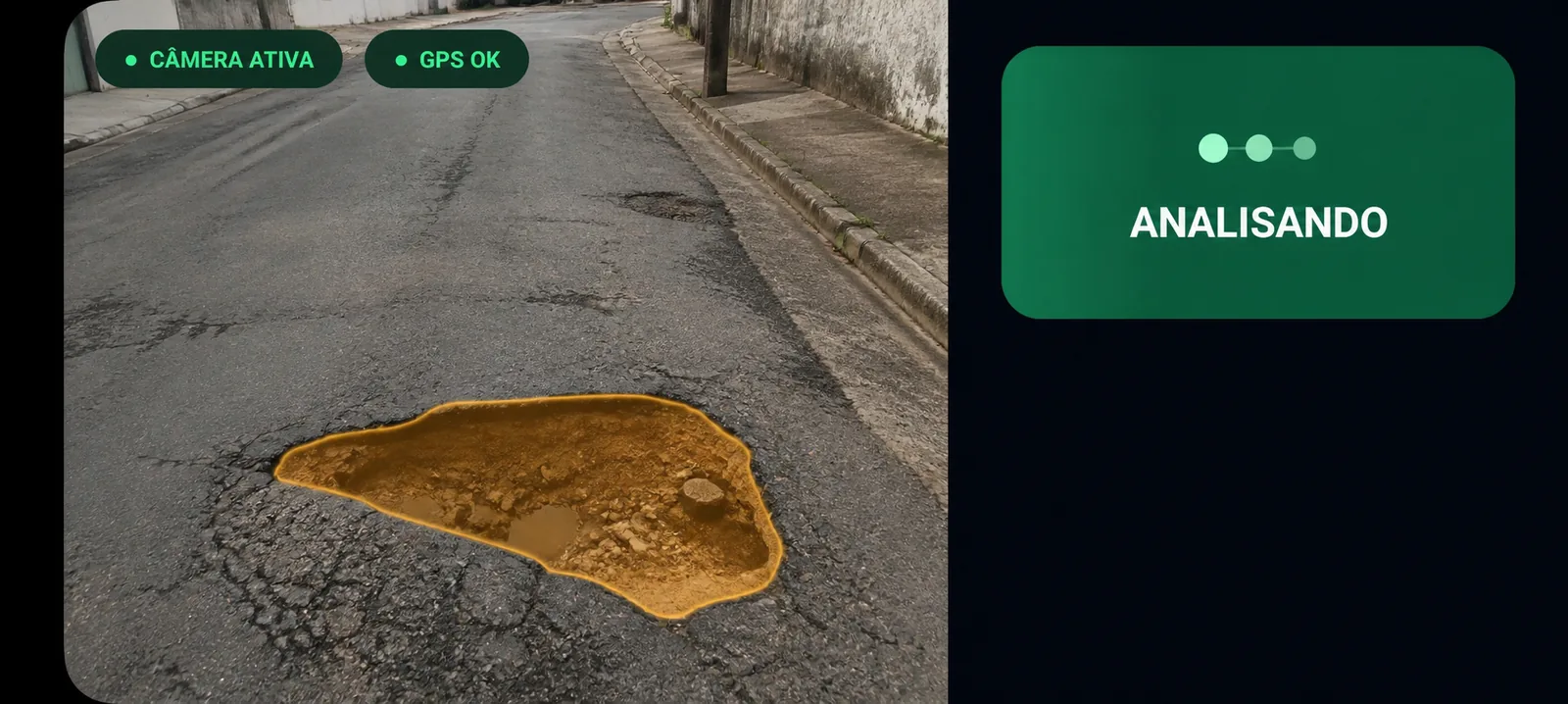
Mobile capture and central AI
The field application shows only what the team needs to record the scene. Most inference runs in Areatec's high-capacity AI-accelerated infrastructure.
Models process images, organize classes and return results to the mosaic, map and project-defined workflows.
Operational mosaic and map
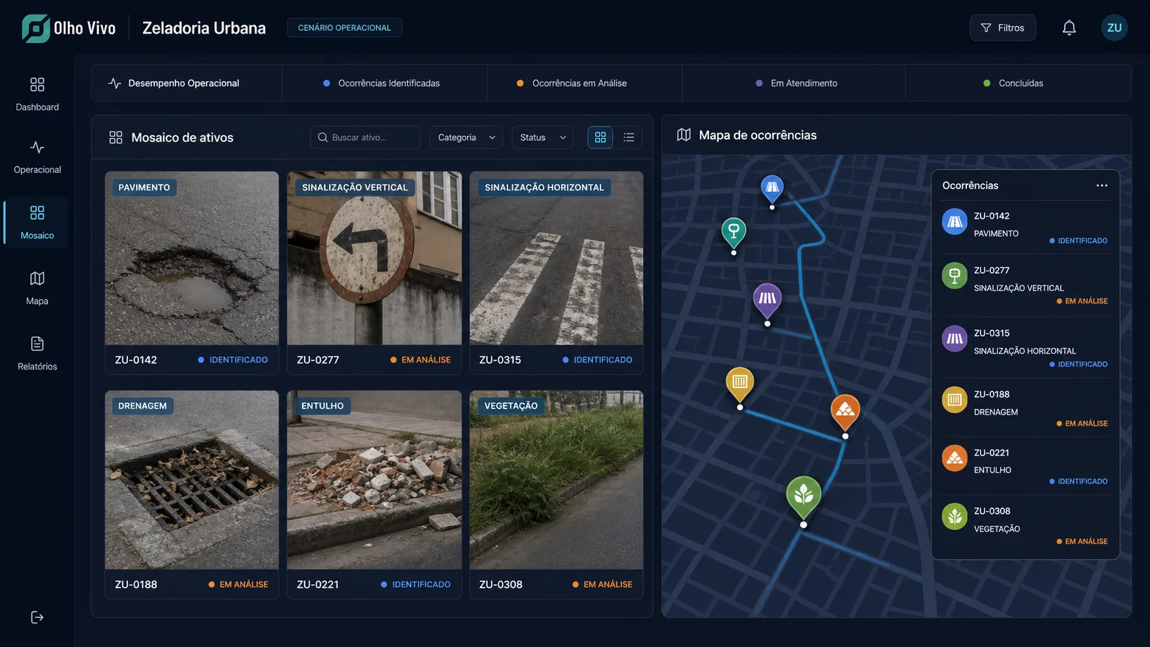
The interface organizes signals by category, route, date, source and treatment status. The mosaic brings captures together, while the map places occurrences across the territory, enables asset filters and supports comparisons between segments and later inspections.
Capability atlas
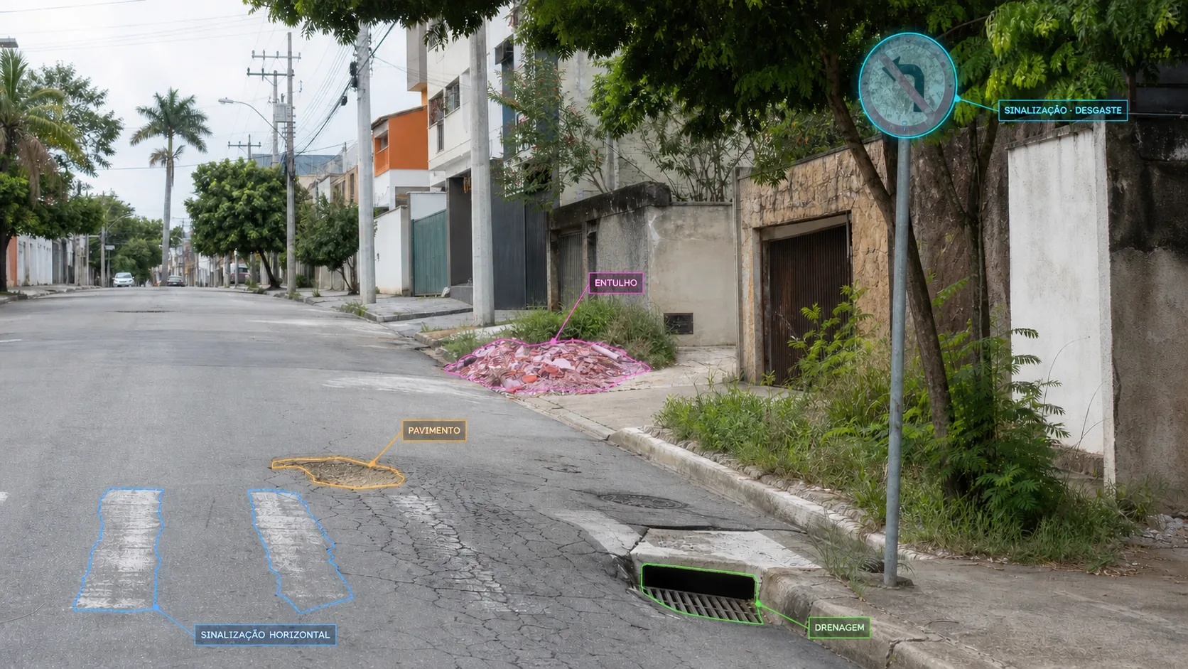
Each group contains visible signals that can be located, classified and contextualized according to the project's technical scope.
Pavement
Locates potholes, patches, cracks, deformation, surface wear and apparent unevenness for organization and follow-up.
Vertical signage
Organizes regulatory, warning and information signs by category, position, visibility, obstruction, damage, wear and apparent orientation.
Horizontal signage
Records lines, lanes, arrows, legends, crossings and other road markings, including segments with apparent wear or loss.
Drainage
Identifies drainage elements, obstructions and apparent accumulation that need to enter the inspection workflow.
Accessibility
Organizes ramps, lowered curbs, tactile paving and observable obstructions without automatically declaring regulatory compliance.
Cleaning and environment
Locates illegal dumping, waste, debris, invasive vegetation and obstruction in public spaces.
Urban assets
Inventories poles, lights, traffic signals, guardrails, shelters, benches, bins and other contract-defined assets.
Concession roads
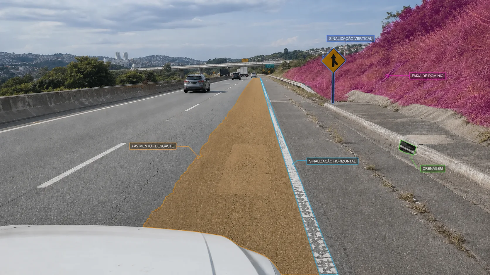
On concession roads, Areatec supports structured field surveys and georeferenced evidence for pavement, horizontal and vertical signage, drainage, protection elements, lighting, right-of-way and other groups defined by the contract. The operation can repeat routes, compare segments and organize information according to the road operating program, frequency and criteria applicable to each concession.
The system helps locate, organize and follow occurrences. Tests, inspections by accredited bodies, technical reports and professional responsibility continue to be performed whenever required by the contract or applicable rule.
Road signage · inventory and visible condition
The same pass organizes signage found across the territory and preserves the image, position and context for technical review. The inventory can include signs, lines, lanes, arrows, legends, crossings and other elements defined in the operation's scope.
Operational foundation
The architecture connects field work, central processing and institutional management without exposing technical complexity to the inspection team.
Operation
Mosaic, map, filters, history and workflows organize incoming volume and the treatment defined by the authority.
Explore Olho Vivo CityContext
Authenticated geolocation can link position, time, movement and device signals to the record when included in the project.
Explore PintrustIntegrity
Digital fingerprints and event chaining preserve integrity and sequence whenever chain of custody is part of the scope.
Explore AreaChainIntegration
Reviewed records can proceed to authorized platforms and systems with fields, authentication and returns defined for each integration.
Plan an integrationAreatec ecosystem
Explore the technologies that support capture, analysis and issue follow-up across the operation.
Buyer's guide
Start with the work your team needs to complete. Request intake, road inspection and service delivery management have different scopes. Ask vendors to demonstrate how those parts work together.
Areatec combines AI inspection, asset inventory and native requests with optional APIs. Use these criteria to assess fit for your operation; a feature list alone does not prove field results.
Frequently asked questions
The scope may include pavement, vertical and horizontal signage, drainage, accessibility, cleaning, waste, vegetation and urban assets such as lighting, poles, traffic lights, guardrails, shelters, benches and bins. Observable classes and criteria are defined for each operation.
The field application brings together framing, position, time and a preliminary category. Intensive processing takes place in Areatec's central infrastructure and the results return to the mosaic, map and workflows defined for the operation.
Technology locates, classifies and organizes observable signals. Contractual criteria, diagnosis, priority, reports and technical responsibility remain with people and competent authorities whenever required by the applicable rule or contract.
The operation repeats routes and organizes georeferenced evidence for pavement, signage, drainage, protection elements, lighting, right-of-way and other groups defined by the contract. Frequency, criteria and deliverables follow the road operating program and each concession's requirements.
Yes. Areatec provides APIs to connect with legacy or third-party systems when the customer wants to keep those systems. Fields, authentication, return flows and contingencies are defined for each project. Integration is optional: the platform also includes native service request management.
No. Under Brazil's Traffic Signage Manual, R-6b indicates regulated parking and means that parking is permitted. Category, time limits, charging, boundaries and other conditions depend on supplementary information and the signed segment. Mapping organizes the image, location and context for review; by itself, it does not establish the rule, an infringement or an automatic citation.
Existing sources can be incorporated when they are compatible with project requirements. Positioning, image quality, geographic context, connectivity, security and processing capacity are defined before operational configuration.
Each project begins with defined purpose, scope and access profiles. The architecture can apply minimization, event records, retention, disposal, authenticated geolocation and an integrity chain according to the authority's needs and applicable law.
Areatec includes native service request management alongside AI inspection and asset inventory. Managing requests does not require a third-party system. When the customer prefers to retain legacy or third-party systems, Areatec provides integration APIs with a project-defined scope.
Technical assessment
Areatec supports contracting, deployment and customer support for projects in the United States and Canada, as well as Brazil and Latin America. Tell us which assets need inspection and whether you need native service request management or integration.