Defined scope
Routes, categories and capture conditions are agreed for each operation.
SPECIALIST CAPABILITY · URBAN PAVEMENT
Authorized imagery can flag visual signs of potholes, cracks, patches and subsidence along configured routes. Each record brings together available evidence and location context for technical review; it does not replace field inspection, measurement or an engineering report.
This page covers the triage of pavement indications. The urban-maintenance platform and the mobile enforcement vehicle have separate responsibilities.
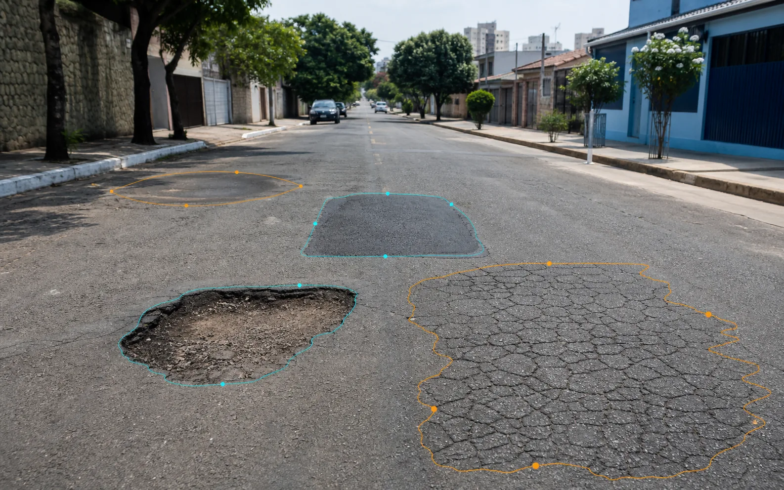
Routes, categories and capture conditions are agreed for each operation.
A record may bring together imagery, position, route and time, depending on the available configuration.
The indication supports triage. Technical decisions and action remain with the competent owner.
Quality, coverage and integration are verified on the contracted configuration.
FROM ROUTE TO REVIEW
Visual capture can reduce the effort spent looking for occurrences without context. It does not remove the technical steps needed to confirm cause, dimensions, risk or remedy.
Cameras and sources specified in the project record pavement along the routes and under the conditions defined for the operation.
Computer vision marks regions with patterns compatible with configured categories without declaring a final diagnosis.
Available imagery and location data are organized to support comparison, review and, when needed, a return to the location.
An authorized person confirms the treatment. Compatible integrations can route the record into the municipal workflow.
WHAT MAY ENTER TRIAGE
The contracted set may separate different patterns instead of recording every surface change as a “pothole”. Feasibility for each category depends on the imagery and acceptance criteria.
Apparent material loss and visible cavities that warrant field confirmation.
Linear or interconnected patterns that can feed a dedicated inspection queue.
Previously repaired areas with visible differences in edges, texture or apparent condition.
Visible surface changes that require measurement to determine size, cause and severity.
CONTRACT AND FIELD TEST
Accuracy, location precision, processing rate and coverage should not be treated as universal guarantees. A useful comparison starts with a representative sample and criteria recorded before testing.
Included categories and examples of what remains out of scope.
Routes, speed, cameras, lighting and weather conditions assessed.
Review threshold, false positives, false negatives and sampling method.
Minimum location quality required for the intended purpose.
Validation owners and rules for routing or integration.
CLEAR RESPONSIBILITIES
Separating these functions helps a city procure what it actually needs and define acceptance criteria for each part.
Organizes visual indications of pavement defects for triage and review.
You are on this pageThe complete mobile capture and enforcement vehicle, composed for the contracted modules and operation.
Explore the vehicleThe platform for records, human review, priorities, integrations and occurrence follow-up.
Explore the platformTECHNICAL REFERENCE
DNIT standard 005/2003 — TER is a public reference for the names and definitions of defects in flexible and semi-rigid pavements. Using its vocabulary does not turn a visual classification into an inspection, measurement, engineering report or automatic compliance.
Read the DNIT publicationQUESTIONS FOR TECHNICAL ASSESSMENT
No. Authorized imagery can produce georeferenced indications for triage. Confirming and measuring the defect, assigning a final classification, setting priority and choosing a remedy require the process and qualified professionals defined by the municipality. A visual record is not an engineering report.
Automatic compliance is not assumed. The terminology in DNIT standard 005/2003 may guide project categories, but an image does not replace measurements, field surveys or the technical criteria required for each purpose. Category use and acceptance criteria must be defined in the contract.
There is no responsible universal percentage. Results vary with the camera, its position, lighting, speed, road condition, occlusions and the categories in scope. Each project should measure quality on a representative sample and record thresholds, false positives, false negatives and acceptance-test conditions.
That is not published as a universal guarantee. Location quality depends on sensors, installation, the environment and available sources. The required accuracy must be defined for the intended use and demonstrated on the contracted configuration during acceptance testing.
Not by default. When the systems involved provide compatible interfaces, the record may be routed to a review queue or a work-order workflow. The municipality defines owners, validations, priorities and which steps may be automated.
Capture conditions affect the result. Lighting, reflections, water on the road, dirt, shadows, speed and occlusions must be included in the test plan. The operation should rely only on coverage and quality verified for the contracted conditions.
Pothole Detection is the specialist capability that organizes visual indications from the pavement. Olho Vivo Patrol is the complete mobile capture and enforcement vehicle, depending on the contracted modules. Urban Maintenance is the broader platform for records, human review, priorities, integrations and follow-up. A solution may combine all three without confusing their responsibilities.
A consistent proposal starts with routes, categories, evidence, review rules, integration and acceptance testing. With that scope, Areatec can assess a suitable configuration without applying a laboratory number to every city.
Talk to Areatec