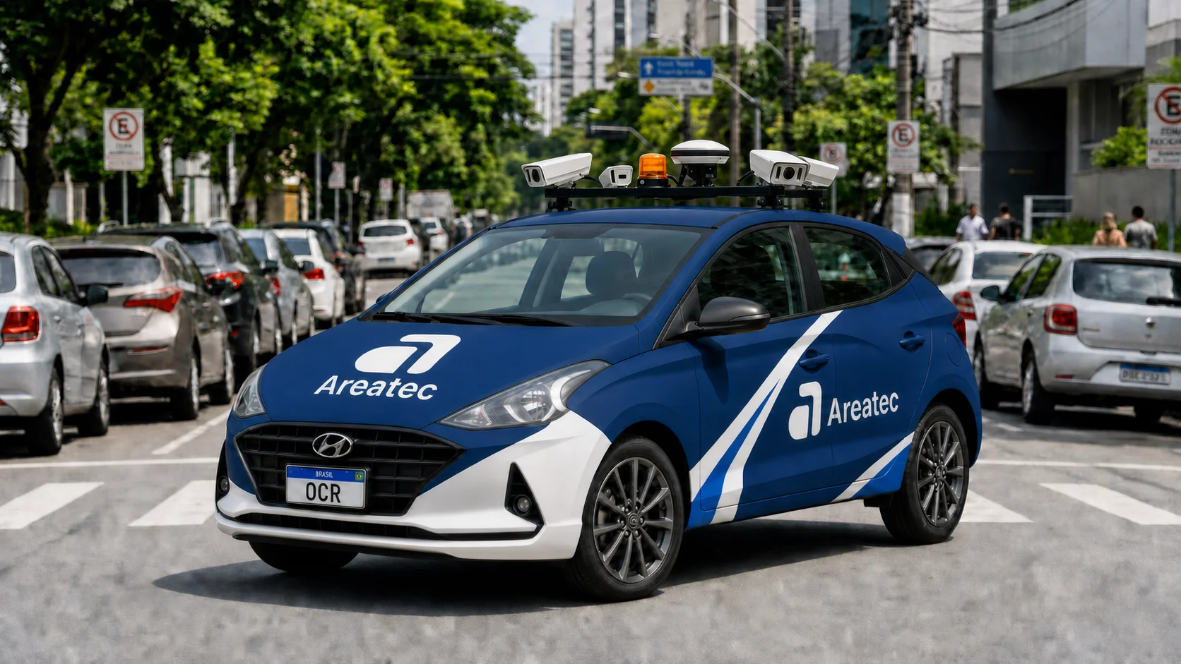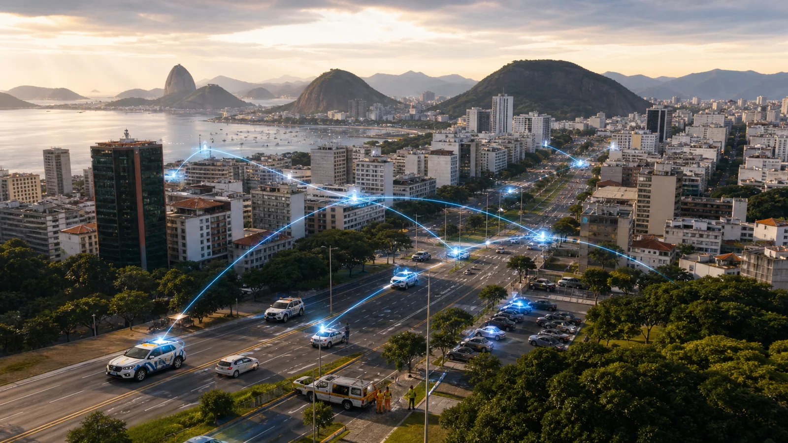
At 7:42 a.m. on an autumn Tuesday in 2032, Avenida Brasil, one of the city's most pulsing arteries, breathes in a perfectly coordinated rhythm. The asphalt seems alive. Beneath the gray surface, electromagnetic ground sensors register the weight and speed of every vehicle. On the metal poles of the public lighting, small gray boxes equipped with ultra-high-definition optical lenses and ambient microphones sweep the scene. An electric patrol vehicle glides silently along the right lane. Its compact cameras perform instantaneous license plate readings at sixty frames per second, processing data locally with minimal energy consumption.
At that exact moment, two hundred meters ahead, an imperceptible vibration occurs underground. The constant passage of heavy buses has started a microcrack in the asphalt base, just above an old stormwater pipe. To a human observer, the street looks flawless. Yet the urban system already knows what is going to happen.
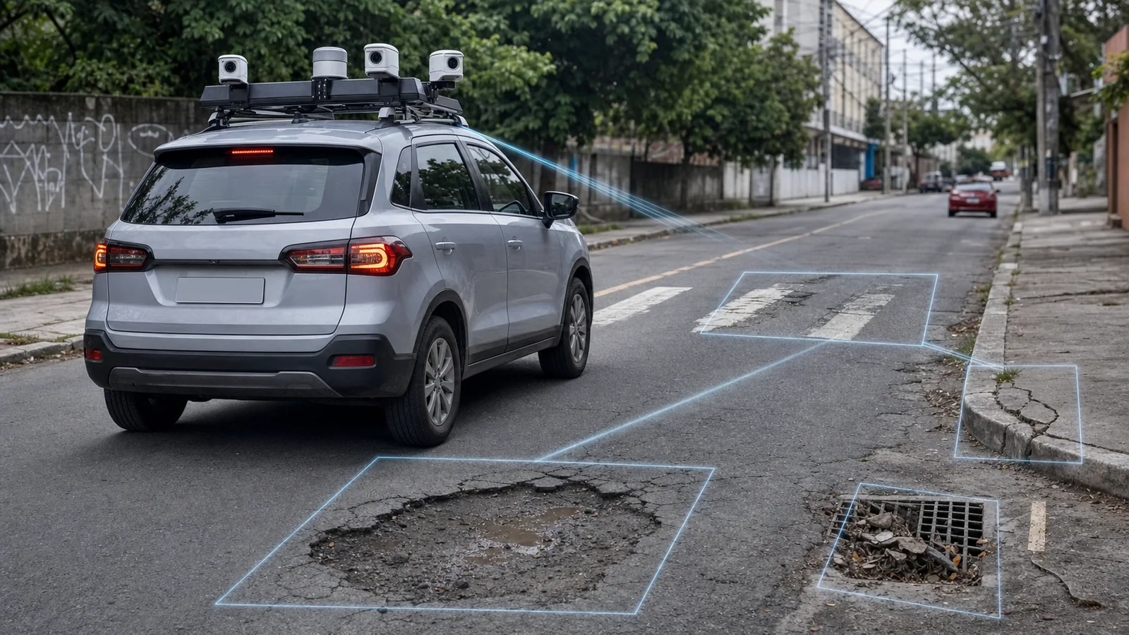
The computer-vision camera installed on pole 147 detected a subtle change in the pattern of sunlight reflecting off the damp asphalt. The coupled acoustic sensor registered a low-frequency crack when a truck tire passed over the spot. Simultaneously, the OCR patrol vehicle that crossed the road three minutes earlier sent a three-dimensional scan of the surface. The city's digital brain cross-referenced this data with the soil moisture history provided by the meteorological sensors and with the underground pipe map from the Department of Public Works.
The diagnosis is immediate and predictive. The system calculates an 87% probability that a large pothole will open at that exact point within the next forty-eight hours due to subsurface erosion. Even before the first chip of asphalt comes loose, a work order is automatically generated on the dashboard of the Department of Urban Infrastructure. A preventive maintenance crew is scheduled to intervene at two o'clock the following morning, the period of lowest traffic flow. Traffic will not be interrupted. No driver will suffer an accident. No tire will be torn. The problem was solved before it even existed in the physical world.
This invisible, hyperconnected metropolis does not belong to the yellowed pages of a book by Isaac Asimov or Arthur C. Clarke. It is being paved right now, piece by piece, by the cutting-edge technologies operating silently on Brazilian streets.
Sensor Fusion: The Eyes, Ears, and Nerves of the Infrastructure
For an artificial intelligence to predict the future of a city, it must first sense the present in its entirety. Traditional traffic-engineering approaches fail because they treat the city in a fragmented way. The traffic department monitors isolated cameras; the public works department analyzes manual citizen complaints; the public transit concessionaire tracks only its own buses. This fragmentation creates catastrophic blind spots.
The true urban revolution lies in the fusion of multiple sensory channels. The AreaDetect system, developed by Areatec, works like the unified nervous system of a living organism. It does not rely on a single source of information. Instead, AreaDetect performs real-time data fusion from a vast range of peripheral devices spread across the urban grid.
| Sensory Channel | Capture Device | Type of Data Processed | Direct Application in Urban Maintenance |
|---|---|---|---|
| Computer Vision | OCR and Olho Vivo cameras | HD video stream, license plate reading in motion | Detection of bottlenecks, suspicious vehicles, and dynamic violations |
| Acoustic Sensing | High-frequency ambient microphones | Noise patterns, structural cracks, sudden braking | Identification of imminent accidents and asphalt wear |
| Ground IoT | Electromagnetic parking sensors | Physical occupancy of spaces, dwell time | Management of rotating parking and reduction of search traffic |
| Three-Dimensional Scanning | Sensors embedded in OCR vehicles | 3D modeling of the roadway, suspension telemetry | Mapping of pavement deformities and lane wear |
| Environmental Data | Meteorological and air-quality sensors | Temperature, relative humidity, CO2 and VOC levels | Correlation between climate and road grip or asphalt degradation |
This multi-channel sensory architecture allows the system to create a continuous, three-dimensional mathematical representation of the city. If an optical camera loses visibility due to a heavy torrential rain, the acoustic sensors and the telemetry data from vehicles circulating on the road compensate for the lost information. Sensor fusion ensures that the city never goes blind, regardless of weather conditions or infrastructure instabilities.
Aretron: The Brain That Anticipates Chaos
Reacting to an urban problem is a sign of technological lag. By the time a traffic crew is dispatched to untie a congestion knot on Avenida Paulista or Avenida de Mayo, the economic loss and citizen stress have already accumulated for hours. By the time a crater opens on an expressway and damages dozens of vehicles, the city government has already failed in its maintenance mission.
The Aretron artificial intelligence engine was designed to break this reactive cycle. Operating in a hybrid structure of edge computing on the OCR vehicles themselves and centralized cloud processing, Aretron acts as the cerebral cortex of this urban structure. It analyzes the massive data flows generated by AreaDetect to identify the subtle patterns that precede chaos.
Using recurrent neural networks of the LSTM (Long Short-Term Memory) type, which are highly specialized in processing complex time series, Aretron projects traffic behavior with mathematical precision. The system can identify that the combination of a light drizzle in the north zone, a four-minute delay on the circular bus line, and a 5% increase in vehicle flow on a secondary road will cause a complete gridlock on a major avenue three kilometers away in exactly twenty-five minutes.
With this predictive information, Aretron initiates autonomous mitigating actions:
- It dynamically adjusts the timing of smart traffic lights along the affected corridor to drain traffic before saturation occurs.
- It sends geo-referenced alerts to navigation apps such as Waze, suggesting alternative routes for drivers approaching the region.
- It changes the digital signage on the roadway's information panels to reduce the speed limit, avoiding the accordion effect that causes rear-end collisions.
In the area of public asset maintenance, Aretron analyzes the continuous degradation of roadways. Every time an Areatec OCR vehicle travels down a street, its sensors perform a millimetric scan of the pavement. The AI algorithm compares these scans with the accumulated history. Upon detecting that the asphalt of a particular curve is losing grip at an accelerated rate due to the flow of heavy vehicles, Aretron schedules preventive resurfacing long before the asphalt breaks apart or a skidding accident occurs on rainy days.
AreaDetect as a Unified Urban Management Platform
The greatest challenge facing contemporary municipal administrations is the technological patchwork quilt. Each supplier delivers a closed, proprietary system that does not communicate with the city's other tools. The result is an inefficient digital bureaucracy, where human operators must monitor ten different screens to try to understand what is happening in the city.
AreaDetect solves this problem by consolidating itself as a unified platform of open, interoperable data. All of the city's sensors — from the simplest speed radar to the most complex underground parking sensor — feed a single integrated ecosystem.
This unification transforms public management into a fluid, automated operation. When AreaDetect identifies an anomaly, the system does not merely display a visual alert on a control panel. It initiates complete operational workflows with no manual human intervention.
If the system detects a vehicle parked in a prohibited spot blocking a bus lane, AreaDetect performs the following actions in milliseconds:
- It validates the violation through the high-precision OCR camera installed on the road, using the DATARACE protocol to guarantee the secure transmission of the image even under unstable cellular network conditions.
- It triggers a notification to the Electronic Ticketing device of the nearest traffic agent, indicating the exact location and the vehicle's license plate.
- It alerts the municipal tow-truck dispatch center so that a unit can move preventively to the location.
- It updates the traffic control panel so that the traffic lights on the previous block slightly hold back the flow of vehicles, preventing the temporary blockage from generating a chain-reaction traffic jam.
All of this coordination happens in the background, silently. Public managers move from being everyday firefighters to strategic planners, monitoring the city's performance indicators in real time through an intuitive dashboard that displays the overall health of the municipality.
The Power of Historical Data and Machine Learning
A newly installed artificial intelligence is like an intelligent child: it has potential, but it lacks experience. Aretron's true predictive differentiator lies in the volume and temporal depth of the data it consumes. It is impossible to replicate the accuracy of an urban predictive model with generic off-the-shelf algorithms or with data collected over just a few weeks.
Areatec operates the largest OCR fleet in the world, processing more than fifty million transactions per month across various Brazilian cities. This massive volume of data accumulated over years creates a knowledge base without parallel in the GovTech market.
When Aretron analyzes the behavior of a road, it is not just looking at what happened yesterday or last week. It cross-references the current scenario with mathematical models refined by years of continuous scans. The system understands how traffic behaves during long holidays, on days with major sporting events, under conditions of extreme rain, or during public transit strikes.
This continuous learning allows the system to avoid false positives. A sudden increase in the number of vehicles on a residential street could be interpreted by an ordinary system as an anomalous traffic jam. Aretron, however, recognizes that this road is historically used as a natural escape route when a nearby main avenue undergoes periodic maintenance, adjusting its predictions and actions according to that refined historical pattern.
The training of the predictive models uses the innovative "Focal Loss" AI technology, developed by Areatec. This computer-vision algorithm is trained specifically to focus on rare violations and anomalies — the critical 1% that causes accidents and gridlocks — while ignoring the common urban visual noise that consumes unnecessary processing capacity. The result is extremely high operational accuracy, with false-positive rates close to zero, ensuring that the system's autonomous decisions are always safe and justified.
The Social Impact: The Invisible City That Cares for the Citizen
The success of a smart city should not be measured by the amount of technology installed on its poles, but rather by the invisibility of that technology in the citizen's life. A truly smart city is one that works so perfectly that its inhabitants simply forget that complex systems are operating behind the scenes.
When AreaDetect and Aretron take over the predictive management of a municipality, the social impact is profound and immediate. Citizens experience a drastic improvement in quality of life through tangible benefits:
- Drastic reduction in commute time: Fewer minutes lost in traffic jams mean more time with family, greater economic productivity, and less daily stress.
- Increased road safety: With traffic lights that adjust to avoid sudden braking and systems that warn about hazards on the road before they become visible, the rate of accidents and pedestrian collisions plummets.
- Proactive urban maintenance: Potholes are filled before they damage vehicles, streetlight bulbs are replaced before the street becomes dark and dangerous, and garbage is collected in an optimized way before the bins overflow.
- Democratization of urban space: Smart parking systems such as Digipare integrated into the ecosystem guide drivers directly to available spaces, reducing the unnecessary traffic of vehicles circling in search of parking, which decreases noise and air pollution in urban centers.
This approach transforms the relationship between the citizen and the public administration. The city government ceases to be a distant entity that reacts belatedly to complaints and becomes an efficient service provider that anticipates the population's needs.
Technology That Works Today to Predict Tomorrow
The future described at the beginning of this article is not a distant promise for the coming decades. It is being built now, in a pragmatic and robust way, on Brazilian streets. While theorists debate abstract concepts of smart cities in air-conditioned classrooms, Areatec applies those concepts in the real world, under the strong sun, the torrential rain, and the most adverse connectivity conditions in the country.
Every OCR vehicle equipped with the Olho Vivo system that circulates through Brazilian cities today, every transaction processed by the Digipare app, and every image analyzed by Areatec's algorithms are actively feeding the predictive brain that will govern the metropolises of tomorrow.
Areatec's philosophy has always been clear: "Technology that works." This means developing solutions that do not depend on ideal laboratory conditions to operate. It means creating protocols like DATARACE, which guarantees the delivery of critical traffic data even when the cellular signal fluctuates in the so-called shadow zones of large cities. It means embedding artificial intelligence at the edge so that enforcement cars keep operating and making decisions even if they completely lose their internet connection.
The smart city of the future will not be built by sudden engineering miracles, but rather by the consistent, integrated evolution of the sensors that are already on the streets today. By unifying these sensors under the AreaDetect platform and processing their data with the analytical power of Aretron, Areatec is not just observing the future of urban mobility. It is writing that future, line by line of code, sensor by sensor, asphalt by asphalt.
References
- Areatec — Technology that works: Brazilian leader in technology for traffic enforcement and rotating parking.
- Smart City IoT Applications & Sensors: A Complete Guide — How IoT applications in smart cities are transforming urban life.
- AI and Machine Learning in Traffic Flow Prediction: Enhancing Urban Mobility — The role of artificial intelligence and machine learning in urban traffic prediction.
- IoT e Cidades Inteligentes: Principais Aplicações e Desafios — How smart cities leverage IoT for efficient management of energy, traffic, and waste.