The Invisible Line That Drew the World
From the 1950s through the 1980s, at the Dahlgren naval base in the state of Virginia, a Black mathematician worked in absolute silence on one of the most ambitious projects in global military and scientific history. Gladys Mae Brown West was born on October 27, 1930, in Sutherland, a rural community in Dinwiddie County, south of Richmond. Born into an African American family of sharecroppers, Gladys grew up picking tobacco and corn under the scorching Virginia sun. Her mother worked in a tobacco factory; her father, on the local railroad. The manual labor in the fields, from dawn until dusk, forged in her an unshakable conviction: education was the only way out of that life.
Gladys graduated as the top student in her high school class and earned a full scholarship to Virginia State College, a historically Black university. She chose to study mathematics — a field dominated by white men — and completed her bachelor's degree in 1952, followed by a master's degree in 1955. In 1956, she was hired by the Naval Proving Ground in Dahlgren. She was the second Black woman to work at that military installation and one of only four Black employees in the entire complex.
Gladys West's work consisted of programming the IBM 7030 Stretch supercomputer — the fastest machine in the world at the time — to process altimetry data from satellites such as Seasat and Geosat. Every line of Fortran IV code she wrote had a clear objective: to eliminate the distortions of Earth's gravity in order to find the precise position of a point in space. The planet, far from being a perfect sphere, presents an irregular surface full of undulations caused by gravitational and tidal forces, a geometric shape known as a geoid. Gladys developed complex algorithms that compensated for these variations, processing billions of calculations on punch cards to build a faithful mathematical model of the Earth's true shape.
Gladys faced racial segregation and professional isolation at a time when recognition was systematically denied to women and minorities. She could not take part in trips or external meetings; her white colleagues received promotions and high-visibility projects while she remained behind the scenes. Her discoveries were kept under military secrecy, and not even her own children knew the importance of the work their mother was carrying out.
"When you're working every day, you're not thinking about what impact it's going to have on the world. You're just thinking: I have to get this right." — Gladys West
In 1986, Gladys published the technical report "Data Processing System Specifications for the GEOSAT Satellite Radar Altimeter," a 51-page document that refined the geoid height calculations using data from the Geosat satellite. This work resulted in the high-precision geodetic model that made the Global Positioning System, the GPS, possible. Without the equations she developed to correct for variations in Earth's gravity and rotation, navigation satellites would make errors of kilometers, rendering any positioning system useless for practical purposes.
Gladys worked 42 years at Dahlgren and retired in 1998. She completed a doctorate in Public Administration from Virginia Tech at the age of 70. Recognition came late: she was inducted into the United States Air Force Hall of Fame in 2018, received the Prince Philip Medal from the British Royal Academy of Engineering in 2021, and the IEEE President's Award in 2024. Gladys West passed away on January 17, 2026, at the age of 95, in Fredericksburg, Virginia.
  +-------------------------------------------------------------+
  |                  THE EVOLUTION OF THE GEOID                 |
  |                                                             |
  |      [ Perfect Sphere ] -> Ignores gravity                  |
  |              v                                              |
  |      [ Reference Ellipsoid ] -> Flat geometric model        |
  |              v                                              |
  |      [ Gladys West's Geoid Model ]                          |
  |        -> Equations of gravity, tides and rotational forces |
  |        -> Basis for the metric precision of modern GPS      |
  +-------------------------------------------------------------+
From Military Supremacy to Global Civilian Dependence
GPS was born as an exclusively military tool developed by the United States Department of Defense. During the early years, the civilian signal was intentionally degraded through a feature called Selective Availability, which limited the precision of coordinates for ordinary users to about one hundred meters. This restriction was eliminated in May 2000, when the American government opened civilian access to the system's metric precision.
This opening triggered a silent technological revolution. The American GPS monopoly stimulated the development of new global satellite navigation constellations, known collectively as GNSS (Global Navigation Satellite Systems). Russia consolidated GLONASS; the European Union developed Galileo, focused on civilian use and high precision; and China established BeiDou, achieving global coverage in 2020.
The table below details the main characteristics of the constellations that orbit the planet and sustain modern infrastructure:
| Constellation | Country / Region of Origin | Operational Status | Main Focus |
|---|---|---|---|
| GPS | United States | Global | Military and Civilian |
| GLONASS | Russia | Global | Military and Civilian |
| Galileo | European Union | Global | Civilian and High Precision |
| BeiDou | China | Global | Military and Civilian |
The fusion of these technologies transformed geolocation into a public utility as essential as electricity or running water. Modern logistics depends on positioning to coordinate truck fleets; civil aviation uses coordinates for landings and takeoffs in extreme conditions; precision agriculture guides autonomous tractors to within millimeters; the financial system synchronizes global banking transactions using the satellites' atomic clocks; and the justice system uses location data as definitive evidence in criminal and civil proceedings. Modern society built its foundations upon a coordinate of latitude and longitude.
The Fragility of Space: The Spoofing Phenomenon
This absolute dependence created a critical vulnerability. Navigation satellites orbit at about twenty thousand kilometers of altitude, emitting radio signals that reach the Earth's surface extremely weak, with power below the electromagnetic background noise. Any GPS receiver, whether in a state-of-the-art smartphone or a cargo tracker, needs to amplify this faint signal to extract the positioning information.
This physical weakness opened the way for GPS spoofing, an attack technique that consists of generating fake satellite signals to deceive the receiver. In the past, this practice required military equipment worth millions of dollars. The scenario changed radically with the popularization of Software-Defined Radios (SDR), electronic devices that can be purchased for less than two hundred dollars on e-commerce websites.
With a portable SDR transmitter and open-source software freely available on the internet, anyone with basic technical knowledge can create a bubble of fake signal around a device. The transmitter generates radio waves identical to the frequencies sent by the original satellites, but with slightly higher power. The GPS receiver of the smartphone or vehicle focuses on the stronger signal and begins to calculate the position based on the false coordinates generated by the attacker.
  +-------------------------------------------------------------+
  |                MECHANICS OF A SPOOFING ATTACK              |
  |                                                             |
  |  [ GNSS Satellites ]      [ SDR Transmitter (R$ 200) ]      |
  |   Weak original signal     Identical and strong fake signal |
  |         \                           /                       |
  |          \                         /                        |
  |           v                       v                         |
  |         [ GPS Receiver of the Target Device ]               |
  |         -> Abandons the weak original signal                |
  |         -> Processes the false coordinates                  |
  |         -> Displays fraudulent location                     |
  +-------------------------------------------------------------+
The practical consequences of this type of fraud are devastating and affect various sectors of the market and public administration:
- Traffic and Transportation Enforcement: Ride-hailing drivers and public transport fleets use location-spoofing apps to fake trips, evade fares, or simulate the completion of routes that were never actually traveled.
- Logistics and Insurance: Gangs specialized in cargo theft use signal simulators to make the monitoring center believe that the truck is still traveling on the main highway, while the actual vehicle has been diverted to a chop shop.
- Electronic Time and Attendance Control: Field employees use simple "Fake GPS" apps to clock in at the start of their workday as if they were at the client's premises, when in fact they are still at home.
- Public Safety and Justice: Digital evidence based on location records extracted from cell phones loses its legal credibility, because the defense can easily claim that the coordinates were manipulated by third parties.
Common geolocation, based solely on the simple reception of commercial GNSS signals, has become an unsafe variable. It does not serve as technical evidence and does not withstand even minimally rigorous judicial scrutiny.
Provloc: Areatec's Answer for Secure Geolocation
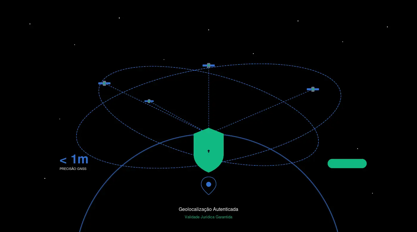
Faced with this scenario of extreme vulnerability, Areatec drew on its thirty years of experience developing technology for the public and private sectors to create Provloc. The goal of the project was to design a solution capable of shielding location data, transforming geographic coordinates into robust, tamper-proof digital evidence with full legal validity within Brazilian territory.
Provloc acts directly at the root of the problem through a layered approach that combines hardware validation, cryptography, and legal compliance. The first line of defense consists of cryptographic authentication of the satellite signal. Instead of passively accepting any coordinate provided by the device's operating system, Provloc performs validation of the origin of the navigation signal.
This validation analyzes the physical characteristics of the received signal, cross-referencing the data with the expected mathematical properties of the active satellite constellations. If a fake signal is generated by a ground-based spoofing transmitter, the system identifies the anomaly in the wave structure and discards the coordinate immediately, halting the fraud attempt at its source.
  +-------------------------------------------------------------+
  |              PROVLOC SECURITY ARCHITECTURE                 |
  |                                                             |
  |  [ GNSS Signals ]                                          |
  |        v                                                    |
  |  [ Cryptographic Signal Validation ]                        |
  |    -> Analyzes the physical origin of the satellite signal  |
  |    -> Blocks fake signals from SDR transmitters             |
  |        v                                                    |
  |  [ Digital Chain of Custody (CPP) ]                          |
  |    -> Preserves data integrity from the moment of capture   |
  |        v                                                    |
  |  [ ICP-Brasil Signature & Timestamp ]                       |
  |    -> Assigns authorship and irrefutable temporal proof     |
  |        v                                                    |
  |  [ Registration on AreaChain ]                              |
  |    -> Mathematical immutability and public auditability     |
  +-------------------------------------------------------------+
The Legal Shield: Chain of Custody and Brazilian Legislation
For digital information to be accepted as evidence in a court of law, it must rigorously respect the chain of custody. In Brazil, this concept was formalized in the Code of Criminal Procedure (CPP) by articles 158-A through 158-F, introduced by Law No. 13,964 of 2019. The legislation defines the chain of custody as the set of procedures used to maintain and document the chronological history of the trace evidence, guaranteeing its integrity and inviolability.
Provloc was structured to fulfill each of the chain-of-custody requirements. The evidence-preservation process follows a strict methodological flow:
- Capture of the Trace: The geographic coordinate is collected directly from the validated navigation hardware, recording the raw metadata from the satellites.
- Isolation and Fixation: The location data is immediately sealed within the application, preventing any interference from the user or from other software installed on the operating system.
- ICP-Brasil Digital Signature: The record receives a digital signature using certificates accredited by the Brazilian Public Key Infrastructure (ICP-Brasil), guaranteeing the authorship and non-repudiation of the information.
- Timestamp (ACT): A Timestamping Authority accredited by the National Institute of Information Technology (ITI) applies a temporal seal to the file. This process attests, with millisecond precision synchronized with official Brazilian time, the exact moment when that coordinate was recorded.
- Secure Storage via AreaChain: The cryptographic hash of the signed data package is recorded on Areatec's private blockchain, AreaChain. This step ensures that any subsequent alteration of even a single bit in the original file invalidates the entire mathematical structure, making the fraud immediately detectable by independent experts.
This technical rigor results in the issuance of a Technical Forensic Geolocation Report. The document consolidates the entire capture history, the digital signatures, the public keys used, and the blockchain record. It is a legal instrument ready to be attached to judicial proceedings, insurance disputes, or fiscal compliance audits.
The Operational Impact in the Real World
Areatec's philosophy has always been guided by the principle that technology must work under the severe conditions of the real world, and not only in the controlled environment of a testing laboratory. Provloc was designed to operate efficiently even in scenarios of unstable connectivity, cellular network coverage shadows, and adverse weather conditions.
The system stores the signed and timestamped data packages locally when no internet signal is available. As soon as the device reestablishes its connection to the network, the transmission to the blockchain is completed without any break in the chain of custody or loss of the record's temporal validity. This operational resilience is critical for Areatec's OCR vehicles, which travel thousands of kilometers per month in urban areas where mobile data coverage oscillates between full 4G and zones of absolute shadow.
Practical Applications and Use Cases
Provloc was conceived to serve multiple scenarios where proof of location must withstand legal and technical scrutiny:
Electronic Traffic Enforcement: Speed-measuring equipment and video-monitoring systems generate infraction records linked to geographic coordinates. With Provloc, each citation carries with it cryptographic proof that the equipment was positioned exactly at the location approved by INMETRO and SENATRAN at the moment of capture.
Digital Paid Parking: Blue-zone enforcement agents use mobile devices to record irregularities. Provloc guarantees that the agent was physically present at the indicated block face at the moment of the record, eliminating claims of fraud or improper remote citation.
Urban Maintenance and Validation of Incidents: When an Areatec OCR vehicle is dispatched to validate a report of a pothole, illegal trash, or damaged signage, Provloc proves that the team was at the exact location of the incident, generating georeferenced photographic evidence with forensic validity.
Logistics and Fleet Tracking: High-value cargo transport companies can use Provloc to generate route evidence that withstands challenges from insurers in the event of a claim. The authenticated coordinate proves that the vehicle followed the contracted itinerary.
Electronic Ankle Monitor Monitoring: Public security agencies can integrate Provloc into the monitoring systems of inmates in semi-open regimes, guaranteeing that the location data presented in court was not tampered with by spoofing devices.
The Legacy of Gladys West and the Future of Secure Geolocation
The adoption of Provloc redefines the security standard for smart cities and modern public administration. By guaranteeing that a traffic enforcement vehicle was exactly at the indicated intersection at the moment of the citation, or that an OCR car carried out the validation of an urban maintenance incident without deviations, the platform eliminates the loopholes for judicial challenges and protects public funds.
The history of geolocation began with a Black woman calculating the shape of the Earth on punch cards, facing racism and professional invisibility for four decades. Gladys West proved that precision is born of persistence and that mathematics does not discriminate. Areatec inherited that spirit by transforming vulnerable coordinates into evidence shielded by cryptography and law.
The technology developed by Areatec closes the gap opened by the evolution of digital fraud tools. Geolocation ceases to be vulnerable declaratory information and becomes unquestionable technical evidence, protected by the same laws of mathematics and cryptography that Gladys West helped to pioneer in the last century.